Natural Language Understanding & Generation
【 Generative AI × Domain Knowledge Base: Intelligent Knowledge & Decision Support】
EGIT has developed a hybrid AI service platform tailored for use by government and enterprises, combining on-site data protection with cloud computing capabilities. By integrating Natural Language Processing (NLP) with Retrieval-Augmented Generation (RAG), we help organizations build secure, domain-specific knowledge bases.
The system uses precise semantic retrieval and knowledge extraction to deliver intelligent search, content generation, and knowledge insights, while maintaining strict data security and system scalability. This enhances traceability and reliability, enabling organizations to fully leverage their existing data assets for smarter decision-making.
Hybrid AI Architecture: Balancing Security and Performance
Our hybrid large language model (LLM) architecture combines on-site deployment with cloud integration. Sensitive data is preprocessed through de-identification and key information extraction before being securely transmitted to cloud-based models. This approach significantly reduces data-transfer loads while improving AI performance and ensuring information security for applications in both government and enterprises.
Deep Semantic Understanding & Data as a Service (DaaS)
This solution supports a wide range of applications, including intelligent customer service, document classification, knowledge Q&A, and voice assistants. The system accurately interprets natural language input, identifies synonyms, extracts key terms, and triggers corresponding functions to enable efficient Data as a Service (DaaS):
- Accurate Retrieval & Data Visualization :
Using RAG technology, responses are strictly grounded in internal data sources, effectively eliminating the risk of ungrounded outputs. Users can use intuitive queries to quickly obtain precise information. The system can also transform complex datasets into structured formats and visual charts, improving usability and decision efficiency.
- Historical Query Tracking :
Built-in query history preserves user interactions and referenced data sources. This allows seamless continuation of workflows, reduces repetitive searches, and enhances operational efficiency and decision-making continuity.
 AI Customer Service Platform :
Integrating intelligent query and data validation technologies, the platform enables rapid access to system information, automated chart generation, and retrieval of historical records.
AI Customer Service Platform :
Integrating intelligent query and data validation technologies, the platform enables rapid access to system information, automated chart generation, and retrieval of historical records.
Application in Large-Scale System Support
This solution is deployed in the Industrial and Sewerage Wastewater Management System (“Water Pollution Control System”), which regulates wastewater discharge and treatment across industrial operations. The platform supports complex workflows, including factory registration, approval of wastewater treatment facility installation plans, discharge monitoring, and periodic reporting. With over 10,000 daily users, it handles applications, modifications, cancellations, and data submissions, which traditionally required substantial customer support resources to address user inquiries and troubleshooting.
With the rapid advancement of AI technologies, EGIT has partnered with the Ministry of Environment to compile and structure years of user inquiries and customer service records from the Water Permit System, and to develop a large-scale language model and an AI-powered chatbot. Users can interact through a chat interface, where the AI interprets context, retrieves accurate answers in real time, and guides users step by step through application processes or helps them resolve issues. This has significantly reduced manual workload and improved system responsiveness.
AI Image Recognition Technologies
【 AI Vision × GIS Integration: Enabling Intelligent Environmental Monitoring】
EGIT integrates deep learning and convolutional neural networks (CNN) to build a high-performance image recognition and analysis engine. The system rapidly processes large-scale image datasets, performing feature detection, automated labeling, and anomaly identification.
By tightly integrating GIS-based spatial positioning, the system accurately maps image data to real-world geographic coordinates. Combined with satellite imagery, UAV aerial surveys, and IoT sensor data, environmental changes and equipment conditions are transformed into spatiotemporal intelligence, empowering organizations to accelerate their transition to smart environmental governance.
Precise Alignment of Image Recognition and 3D Spatial Data
Traditional image recognition lacks spatial context, so it has limited real-world application in environmental management. EGIT overcomes this limitation by integrating AI image recognition with GIS platforms. The system extracts key features and identifies anomalies from large volumes of complex environmental imagery and converts them into georeferenced spatial data. This establishes a strong technical foundation for advanced spatiotemporal analytics and big data applications.
Public Health Application: AI-Based Mosquito Surveillance and Hotspot Alerts
Taiwan is a high-risk region for dengue fever. Monitoring mosquito populations in human environments is critical to prevent outbreaks. EGIT partnered with the National Health Research Institutes (NHRI) to integrate handheld devices, AI-based mosquito image recognition, and GIS platforms into a unified solution. This system supports local governments, including Kaohsiung City, Taipei City, and Pingtung County, conducting mosquito surveillance and capturing real-time distribution data.
High-Accuracy Detection: Trained on tens of thousands of field-collected images of Aedes mosquitoes, the AI model currently achieves 93% consistency in mosquito counting. Field personnel can capture images of mosquito traps using handheld devices, enabling rapid and automated counting and significantly reducing manual effort.
This technology can be integrated with GIS platforms to identify breeding hotspots and support targeted vector-control measures. It provides actionable insights for environmental authorities, enabling effective intervention before outbreaks occur. During Kaohsiung City's 2023 dengue prevention efforts, this solution delivered outstanding results, keeping infection levels significantly below the 2015 peak, which demonstrates the effectiveness of AI-driven public health governance in urban environments.
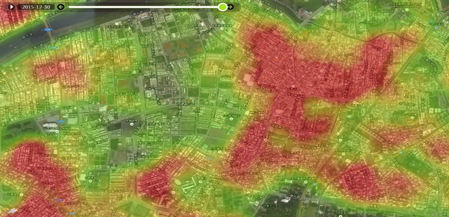 During the 2015 dengue outbreaks in Tainan and Kaohsiung, EGIT supported the development of visualized hotspot maps, enabling real-time identification of high-risk areas and improving response efficiency.
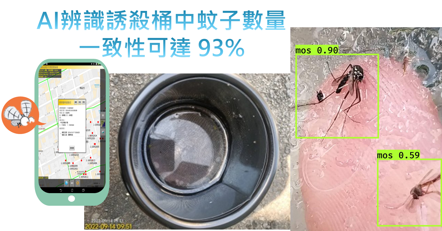 EGIT provides a mobile app to help Kaohsiung frontline personnel carrying out mosquito surveillance. Using handheld devices and AI image recognition, users can capture images from mosquito traps, and the system will produce automatic counts of the mosquito populations with an accuracy of up to 93%.
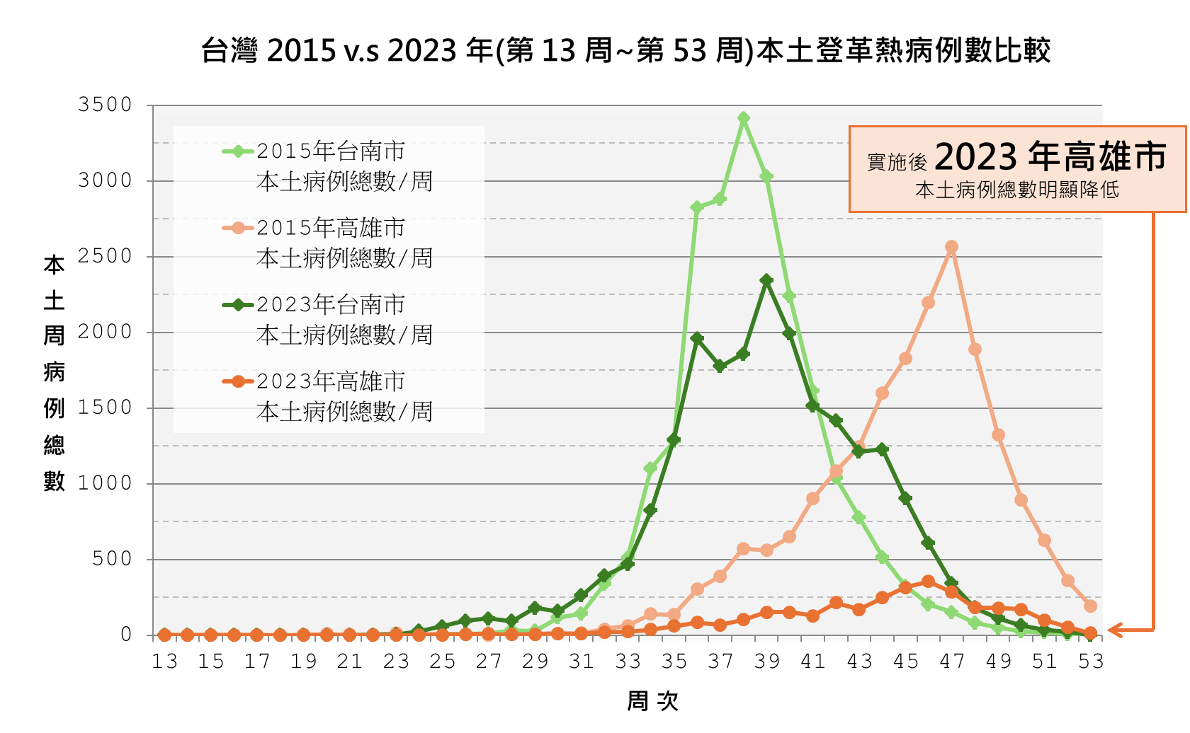 A comparison of dengue data from 2015 and 2023 in Kaohsiung and Tainan shows that, with the integration of handheld devices, AI image recognition, and GIS-based mosquito monitoring, Kaohsiung significantly improved outbreak control, demonstrating the impact of smart environmental governance.
Environmental Management: UAV Surveys & AI Coastal Debris Detection
As an island nation, Taiwan's coastlines are frequently impacted by debris carried by tides and inland waterways. This accumulation affects fisheries, tourism quality, and public safety. To address this, the government launched the "Salute to the Seas" initiative, which aims to ensure that every inch of Taiwan's 1,990 km coastline is properly managed and kept clean.
To support this goal, EGIT has introduced AI technologies into large-scale environmental inspection operations, thus overcoming the inefficiencies of traditional manual surveys and visual screening.
EGIT has been conducting UAV-based coastal aerial surveys for some time now. By integrating image stitching, AI image recognition, and a debris sample database for model training, recognition accuracy has improved to over 80%. The system enables the Ministry of Environment to monitor debris distribution, estimate hotspot locations and affected areas, and issue real-time alerts to responsible agencies for cleanup. This significantly improves environmental management operational efficiency and response speed.
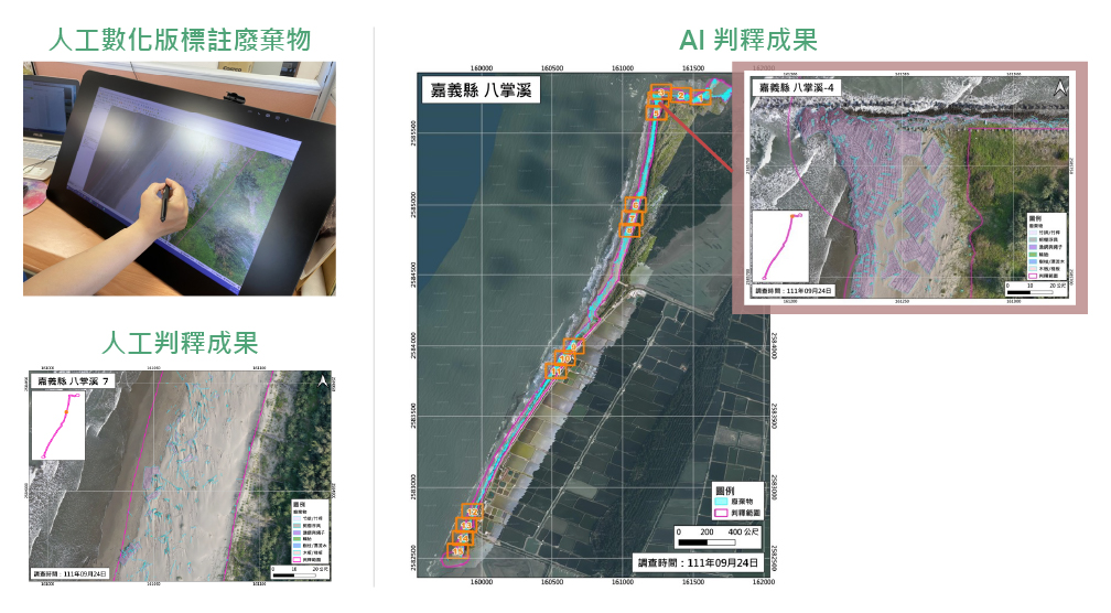 Coastal debris AI model development and training workflow
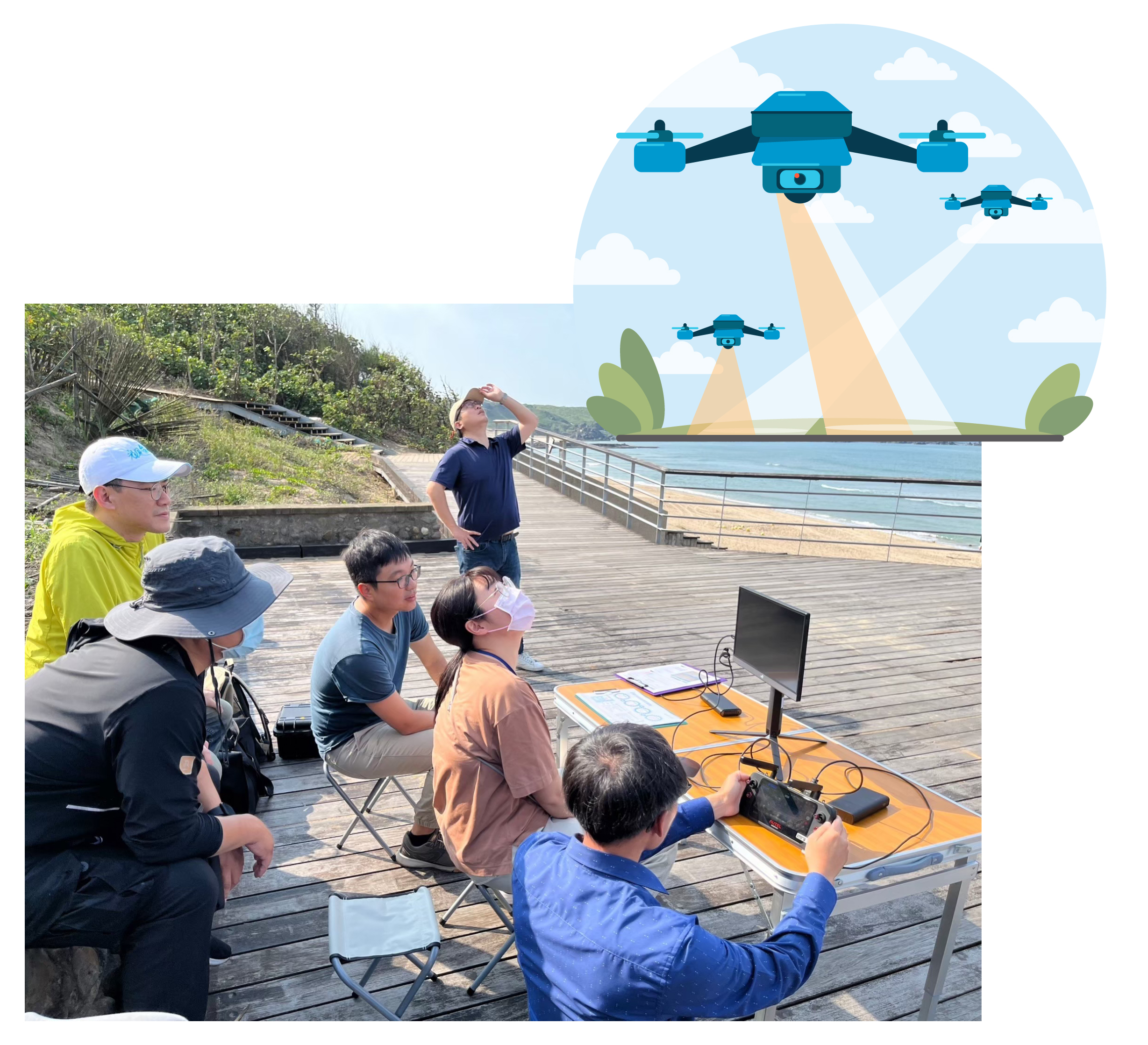 UAV survey operations
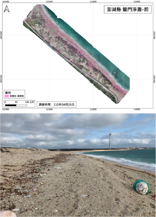 Penghu County, Longmen Beach: Before cleanup
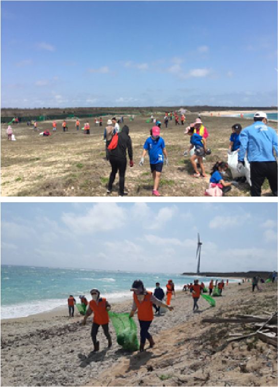 Penghu County, Longmen Beach: During cleanup
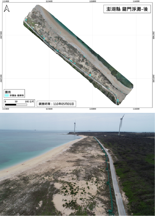 Penghu County, Longmen Beach: After cleanup
Applications in Air Quality Monitoring and Image Quality Management
Since 2010, the Ministry of Environment has been installing CCTV systems at national air-quality monitoring stations, generating a large volume of image data. These records not only support observational data but also provide insights into surrounding environmental and weather conditions. To unlock the value of this data, EGIT uses AI-based image analysis to improve interpretation efficiency and expand analytical applications, strengthening real-time monitoring and intelligent environmental management.
Image Quality Management: Using large-scale image datasets for classification and anomaly labeling, EGIT trains machine-learning models to enable automated detection of lens obstruction, image contamination, and visual anomalies through an AI-assisted recognition system.
Enhancing Data Reliability: Automated image filtering and anomaly detection support station maintenance and data-quality control. This reduces manual workload while improving the reliability and timeliness of monitoring data, providing critical support for smart environmental monitoring.
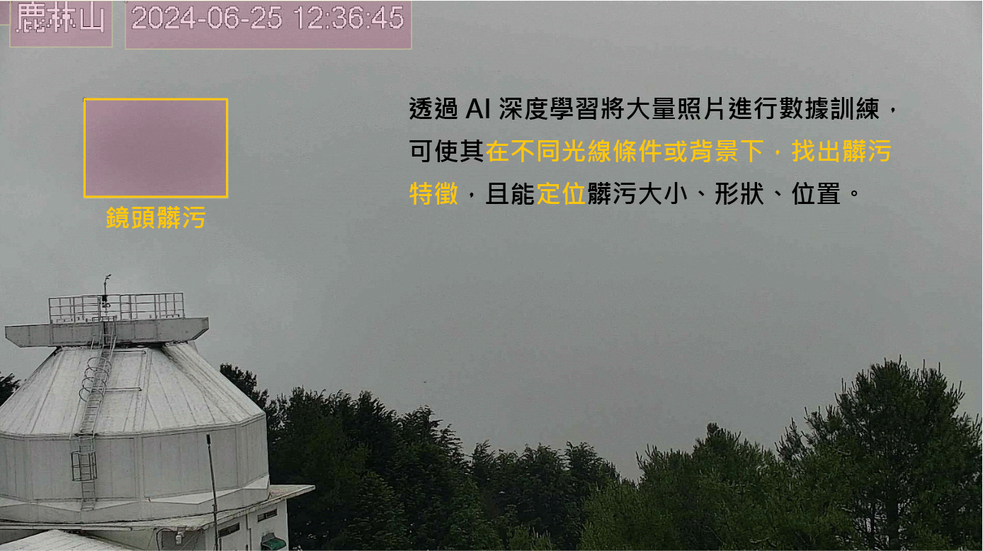 AI-powered image recognition accurately identifies lens contamination in air-quality monitoring footage to improve data quality and maintenance efficiency.
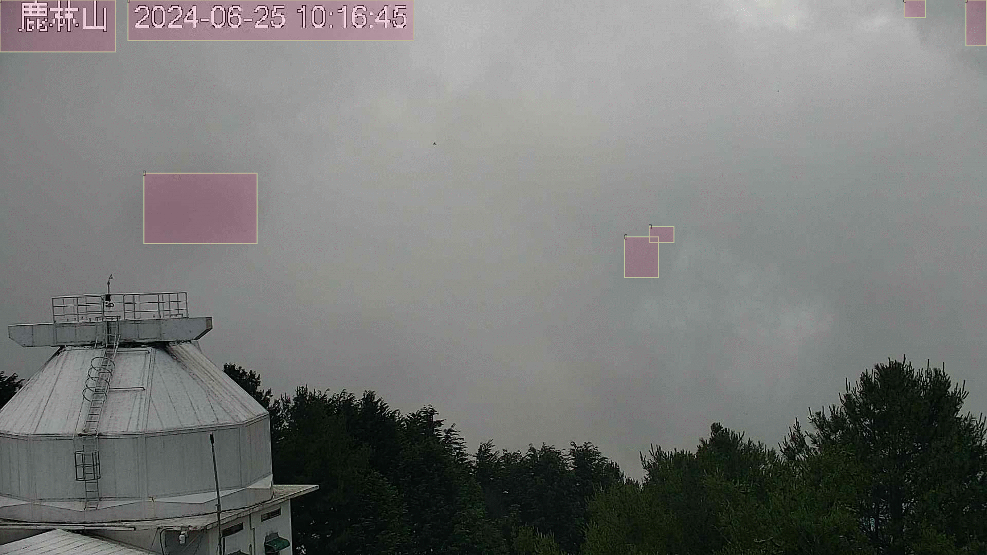 Lens anomaly detection results: the AI system highlights potential abnormal regions, supporting improved image quality and more reliable monitoring decisions.
AI Predictive Analytics
【 Monitoring Data × AI: Environmental Risk & Decision Support】
Environmental monitoring data is not just a historical record. It also serves as a critical basis for trend analysis and risk assessment. EGIT integrates large volumes of monitoring data with statistical modeling and AI inference to analyze patterns and forecast trends.
Using time-series analysis and dynamic parameter calibration, the system improves anomaly detection and translates complex environmental variables into visualized risk indicators. This enables management authorities to identify emerging trends early and make timely, informed decisions.
Building Scientific, Data-Driven Risk Management and Support Mechanisms
With extensive experience in environmental monitoring, EGIT analyzes complex datasets across both time and space. This approach enhances the precision and clarity of data interpretation and helps uncover hidden environmental risks.
In recent years, we have further integrated historical data and statistical methods to analyze anomalies in environmental data. By developing application datasets and applying AI-based predictive models , we have built dynamic forecasting systems that support early detection of monitoring anomalies and transboundary pollution risks , as well as intelligent public health management .
For forecasting risks related to poor air quality and transboundary pollution events, EGIT has developed model architectures with time-series learning, adaptive parameter calibration, and anomaly-detection capabilities. By leveraging large-scale cross-border data, these models identify potential sources, trend variations, and high-risk hotspots. This provides decision-makers with real-time, quantitative, and forward-looking insights, strengthening border monitoring and making resource allocation more efficient.
EGIT is committed to using AI technologies to help government bodies set up scientific, data-driven risk-management frameworks. This improves the accuracy and predictability of risk identification and response, enabling proactive prevention.
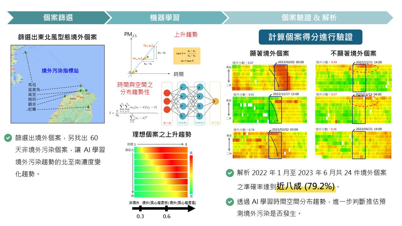 AI-based environmental data prediction and estimation: Integrating statistical modeling with AI inferences to identify pollution sources and temporal trends, thus enhancing early-warning capabilities and risk-response efficiency.